 The City and County of Honolulu prepares and updates 8 Sustainable Communities plans (SCPs) and Development Plans (DPs) for the island of O'ahu. Each of these plans corresponds to one geographic area and serves as a guide for projected growth and future development. The DPs/SCPs are required by City Charter and are adopted by City Council Ordinance.
The sustainable communities plan for the North Shore presents a vision for the North Shore's future development consisting of policies, guidelines, and conceptual schemes that will serve as a policy guide for more detailed zoning maps and regulations and for public and private sector investment decisions.
For more information, please see the Development Plans and Sustainability Communities Plans page on the DPP website.
PROJECT FACT SHEET
View an informative fact sheet that summarizes the project's objectives, main topics, and the ways to get involved.
CITIZENS PLANNING ADVISORY COMMITTEE
Learn more about the NSSCP Citizens Planning Advisory Committee (CPAC) and view CPAC meeting minutes and materials.
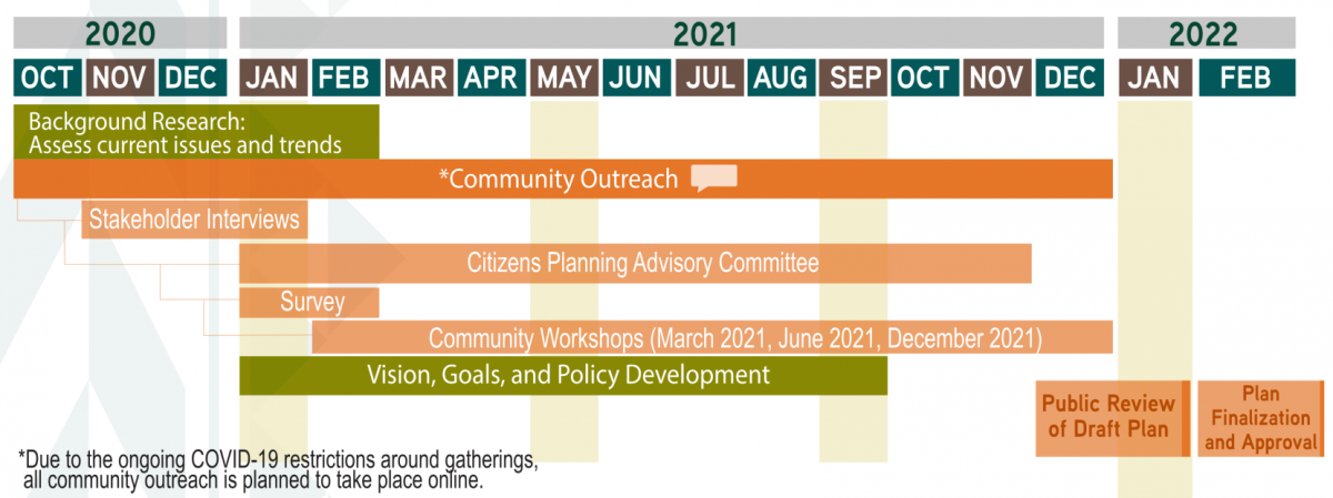
PROJECT SCHEDULE
 The North Shore SCP area extends from Ka‘ena Point in the west to Wai‘alee Gulch near Kawela Bay in the east, with O‘ahu’s shoreline defining the northern edge and Helemano and the slopes of the Wai‘anae and Ko‘olau Mountain ranges forming the southern boundary. North Shore SCP sub-areas include Mokulē‘ia, Waialua (including its uplands), Hale‘iwa, Kawailoa, and Sunset Beach/Pūpūkea. The North Shore is known for its country atmosphere, world-renowned beaches and surf breaks, plantation history, and open agricultural lands set against scenic mountain backdrops.
Zoom in to view the features of each SCP sub-area of the North Shore.