- Please feel free to add comments to our discussion notes from the Climate Change discussion on 6/17 -
- SCROLL DOWN TO VIEW AND PARTICIPATE IN THE CLIMATE CHANGE & RESILIENCE MODULE -
PURPOSE
- Provide CPAC members with information on issues and anticipated impacts of climate change on the North Shore
- Introduce draft climate change goals and policies for the North Shore SCP
- Introduce actions and implementation tools for mitigating the impacts of climate change
- Test “big ideas” for taking steps to adapt to climate change
View and Download the Climate Change & Resilience Fact Sheet below:
View a Presentation on Climate Change Impacts to the North Shore, given by UH Sea Grant at the May 18th CPAC Meeting:
Scroll through the StoryMap below to learn more.
View the presentation for an overview of draft Goals, Policies, Actions & Implementation Tools for the NSSCP, as well as some “Big Ideas” for addressing climate change. Click the play button to listen to the recording.
Click the button below to view and comment on the Goals, Policies and Actions and learn more about the different implementation tools.
LIMIT OR PROHIBIT DEVELOPMENT IN VULNERABLE COASTAL AREAS: As climate change impacts increase in frequency and severity, it will become increasingly unsustainable to continue maintaining development and infrastructure in some vulnerable areas along the coast. Limiting or prohibiting future development or rebuilding in these areas can reduce risks to life and property while preserving and restoring beaches and natural shorelines. This can be achieved by developing a new land use designation or creating an overlay zone for vulnerable coastal areas. For example, Kaua‘i County developed a Special Treatment Coastal Edge (ST-CE) Zoning Overlay district for vulnerable coastal areas as part of its West Kaua‘i Community Plan update. The ST-CE is now being incorporated into the zoning code and permit review requirements. Post-disaster recovery and rebuilding guidelines are also helpful to “build back smarter” and more resilient, or to limit where rebuilding can occur. Maui County has adopted Post-Disaster Reconstruction Guidelines to help achieve this.
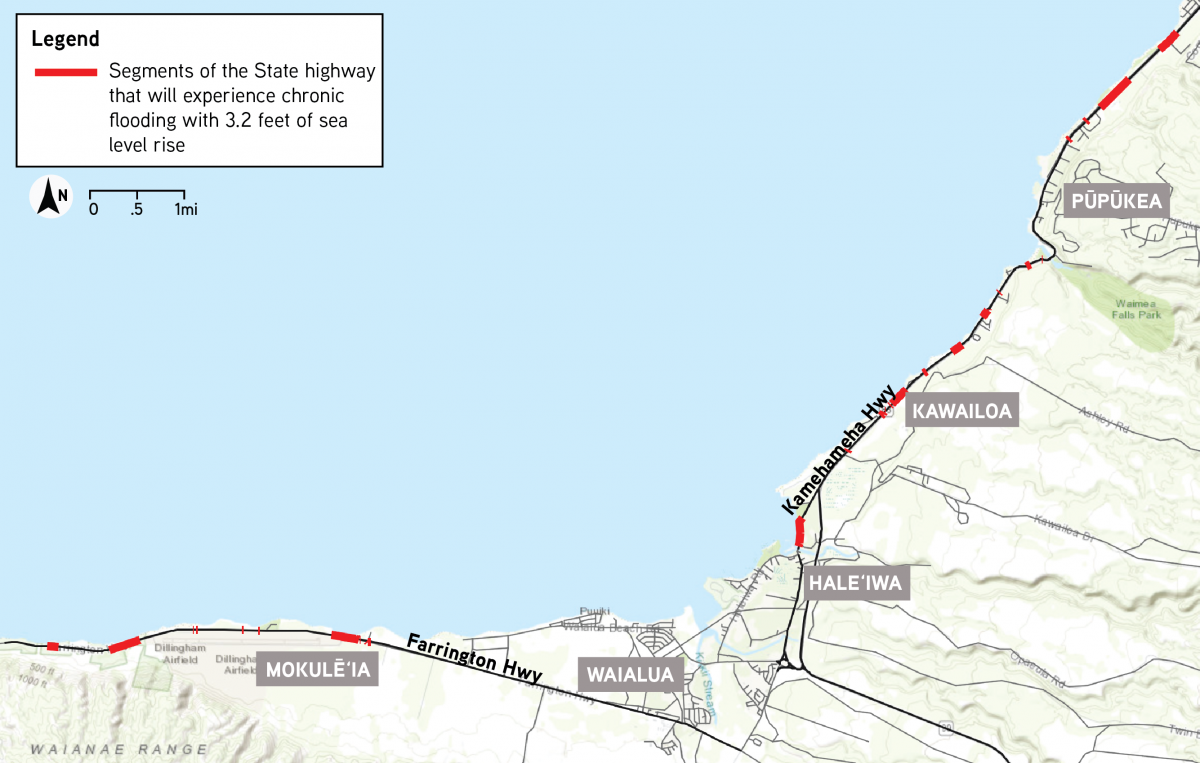
RELOCATE THE HIGHWAY MAUKA: With 3.2 ft of SLR, an estimated 2.9 miles of coastal highway and 5.8 miles of County roads on the North Shore will be chronically inundated, potentially cutting off community access to basic amenities (see map of flooded roadways with 3.2 of SLR). While there may be opportunities to armor or elevate the highway, these measures may not provide long-term protection and can be detrimental to beaches and natural shorelines. The State Department of Transportation (DOT) has begun assessing the feasibility and need for relocating segments of vulnerable coastal highway inland. Relocating the State highway inland will require multi-agency coordination around implications for land use and other utilities that are located within and along roadways. It will also require land acquisition, environmental review, and permitting, which calls for extensive community consultation and outreach.
RELOCATE DISPLACED PEOPLE, DEVELOPMENT, AND INFRASTRUCTURE: An estimated 2,192 residents on the North Shore will be displaced with 3.2 feet of SLR within this century, and 1,310 buildings may be damaged or destroyed. The community will need to help identify and decide where displaced people, development, and infrastructure should go. There are different options to accommodate displaced residents, including identifying areas appropriate for infill development within the Community Growth Boundary, and considering whether to expand the Community Growth Boundary to accommodate people and infrastructure in designated areas. As coastal roads and infrastructure become increasingly threatened, adaptation or realignment options need to be considered to maintain access to the region. See the Climate Change & Resilience Factsheet at the top of this module for maps highlighting the 3.2 feet SLR-XA and the Community Growth Boundary.
PRESERVE & TRANSFORM VULNERABLE AREAS: In addition to deciding how to relocate development away from areas vulnerable to sea level rise, erosion, flooding, and other hazards and protect them from future development, the community will need to help decide how to use and manage these areas in the future. Natural coastlines and floodplains serve important ecological functions and help buffer communities from natural hazards while providing a multitude of cultural, recreational, and social benefits. Examples of potential uses for vulnerable areas include recreation, natural flood protection and retention (wetlands, dunes, coral reef restoration, etc.), public shoreline access, multi-use paths for walking and biking, community gardens, and food sustainability (fishing, gathering, agriculture). Relocating development away from the coast offers opportunities to reimagine coastal areas and how they can serve the community’s vision and goals.
Not sure if you already submitted a response to this survey? Click this link to see your past submissions.
What are your thoughts?
Please use the map to show us what areas you think are most important to address in mitigating the impacts of climate change and natural hazards:
How to use:
- Add a comment by dropping a point:
- Select the appropriate pin and drop it on the map to add your comments. Click on Edit Geometry to move your pin. Type in your comments. Click Save when you're done.
- Add a comment by drawing a line:
- Select the appropriate line and draw it on the map. Click on Edit Geometry to move your line. Type in your comments. Click Save when you're done.
- Use the Hazards Layers
 or Environmental Layers
  list to view and toggle on or off different layers on the map.
State of Hawai'i Sea Level Rise Viewer (PacIOOS)
O'ahu Resilience Strategy (Office of Climate Change, Sustainability, and Resilience (2019)
Statewide Coastal Highways Program Report (Hawai'i Department of Transportation (2019)
Hawai'i Sea Level Rise Vulnerability and Adaptation Report (Hawai'i Climate Change Commission (2017)
Climate Change & Sea Level Rise Technical Resource Paper for the North Shore Communities Plan (UH Sea Grant, 2021) (Pending)